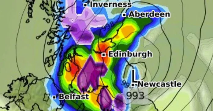
A new set of weather maps show change on the horizon this week as rain and snow are set to batter the British Isles. Up until last weekend, Brits up and down the country had been enjoying the unseasonably warm and bright weather, but Met Office forecasters have warned of change as a mass of wind, rain and even snow are set to make an appearance from today.
The national forecaster predicts a band of heavy rain hitting over Tuesday and Wednesday, and has issued a yellow weather warning for Wales and England – which will be hit hardest. Yesterday, it emerged that as much as five days worth of rain could strike in a matter of hours.
New weather maps from WXCharts for Wednesday show that some parts of the UK will have to contend with flurries of snow amid the drastic downturn. Up to one centimetre of snow is expected to fall on the Scottish HIghlands, while areas like Glasgow and the furthest reaches of northwest England forecast to face between two and three. On Friday, the snow is expected to hit much of the same areas, but also drift further south, with heavy patches of snow making an appearance in Wales and the Lake District.
Additional maps from Windy.com show the direction of the storm’s path this week, as the weather front makes landfall in Weymouth, Dorset before travelling 212 miles and passing over Wales to reach Swadlincote, Derbyshire.
As much as 11mm of rain could fall in a few hours in Ludlow – which is around five days’ worth when compared to averages for April.
Dozens of other communities will be under the yellow weather warning, which activates at 12pm today and continues until the same time tomorrow.
The Met Office believes as much as 75mm of rain will fall on some parts of the country by the time it expires.
The Met Office warns the rain will move westerly, with thunderstorms sparked by the system set to become more “slow-moving” throughout the day.
The warning states: “A spell of heavy and persistent rain is expected to move north across western Britain during Tuesday into early Wednesday.
“Whilst there is some uncertainty in where the heaviest rain will fall, 20 to 40mm of rain is expected fairly widely.
“A few places may see 50 to 75mm of rain during this period: gradually building up in the west following rain on Monday, whilst in parts of the east, falling in shorter periods where heavy showers and thunderstorms become slow-moving.”
The rain seems likely to set off a barmy period for most of the country, with similar conditions following over the next week and into the end of April.
From April 19 to 28, the long-range forecast has predicted additional heavy rain and thunderstorms accompanied by strong winds.
At Reach and across our entities we and our partners use information collected through cookies and other identifiers from your device to improve experience on our site, analyse how it is used and to show personalised advertising. You can opt out of the sale or sharing of your data, at any time clicking the “Do Not Sell or Share my Data” button at the bottom of the webpage. Please note that your preferences are browser specific. Use of our website and any of our services represents your acceptance of the use of cookies and consent to the practices described in our Privacy Notice and Cookie Notice.


